Arcgis Enterprise Overview
ArcGIS Enterprise is a browser-based GIS platform for mapping, data analysis, problem-solving, and data sharing. It is the industry-leading geospatial solution.
Use Cases
Customers recommend Workflow Management, Collaboration, Sending & Publishing Communications, as the business use cases that they have been most satisfied with while using Arcgis Enterprise.
Business Priorities
Scale Best Practices and Improve Stakeholder Relations are the most popular business priorities that customers and associates have achieved using Arcgis Enterprise.
Arcgis Enterprise Use-Cases and Business Priorities: Customer Satisfaction Data
Arcgis Enterprise works with different mediums / channels such as Mobile.
Reviews
"...Enterprise is a comprehensive web-based platform that allows enterprises the ability to collaborate and share data from various sources as services...." Peer review by Mark E
Peer review evidence (same sources as the product rating summary)
"...National integration of workflows, data sharing and IoT. Ability to use various applications and tools to support growth and services...." Peer review by Nicholas K, Business Leader
"...Enterprise seamlessly collaborates with this software-as-a-service app, giving you the same powerful mapping tools in the cloud for your convenience...." ArcGIS Enterprise - Geospatial Platform
"...For example, you can publish a hosted ArcGIS Online or ArcGIS Enterprise Web Feature Service (WFS) from a hosted feature layer and Web Map Tile Service (WMTS) from a tiled layer. ..." Build web apps that use all kinds of data
Arcgis Enterprise, Store Locator Widgets, Loqate, GroundTruth, MetaLocator, etc., all belong to a category of solutions that help Location Based Marketing. Each of them excels in different abilities. Therefore, determining the best platform for your business will depend on your specific needs and requirements.
Popular Business Setting
for Arcgis Enterprise
Top Industries
- Government Administration
- Information Technology and Services
- Non-Profit Organization Management
Popular in
- Enterprise
- Mid Market
- Large Enterprise
Arcgis Enterprise is popular in Government Administration, Information Technology And Services, and Non-Profit Organization Management and is widely used by Enterprise, Mid Market, and Large Enterprise.
Arcgis Enterprise Customer wins, Customer success stories, Case studies
How efficiently Does Arcgis Enterprise manage your Workflow Management?
How can Arcgis Enterprise enhance your Collaboration process?
What solutions does Arcgis Enterprise provide for Sending & Publishing Communications?
10 buyers and buying teams have used Cuspera to assess how well Arcgis Enterprise solved their Location Based Marketing needs. Cuspera uses 155 insights from these buyers along with peer reviews, customer case studies, testimonials, expert blogs and vendor provided installation data to help you assess the fit for your specific Location Based Marketing needs.
What's New in ArcGIS Enterprise 11.2

Peers used Arcgis Enterprise for workflow management and collaboration
Arcgis Enterprise Competitors


Arcgis Enterprise Features
- Low
- Medium
- High
| FEATURE | RATINGS AND REVIEWS |
|---|---|
| Analytics | Read Reviews (17) |
| Custom Reports | Read Reviews (27) |
| CAPABILITIES | RATINGS AND REVIEWS |
|---|---|
| Analytics | Read Reviews (17) |
| Custom Reports | Read Reviews (27) |
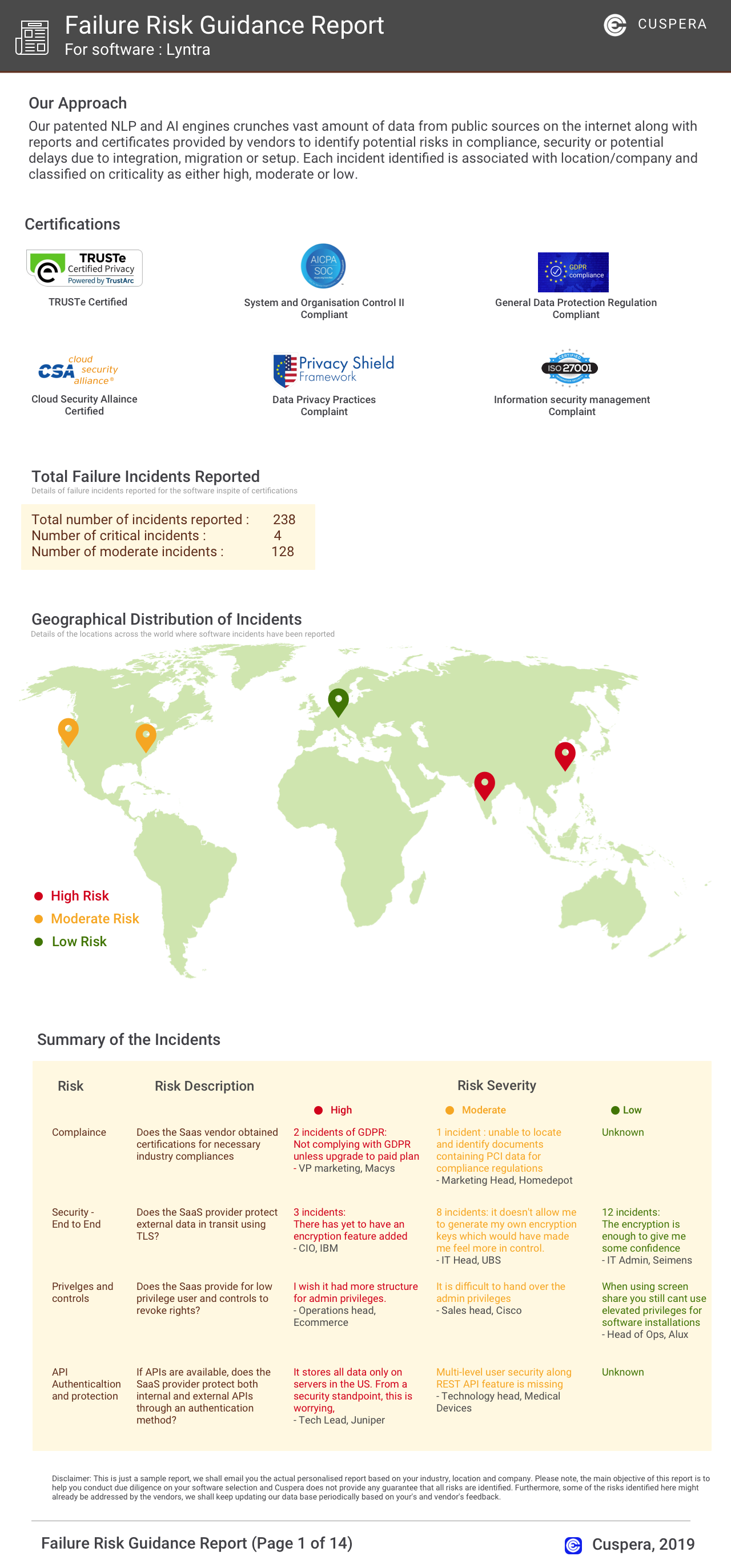
Software Failure Risk Guidance
?for Arcgis Enterprise
Top Failure Risks for Arcgis Enterprise
Esri. News
Geonexus to Preview Geonexus Integration Cloud at Esri User Conference 2026
Geonexus will preview its Geonexus Integration Cloud (GIC) at the Esri User Conference 2026. GIC is a cloud-native geospatial integration platform designed to connect GIS with enterprise systems, enhancing data synchronization and operational alignment. The platform offers visual integration design and event processing, aiming to simplify integration complexity for utilities and asset-intensive organizations.
RSAE Labs Joins Esri Partner Network
RSAE Labs has joined the Esri Partner Network, integrating Esri's GIS technology to enhance its IoT telemetry solutions. This collaboration enables real-time data integration into the ArcGIS ecosystem, providing advanced spatial analytics and AI-driven decision-making for sectors like defense and transportation.
Introducing Esri's Content Life Cycle
Esri introduces its Content Life Cycle, a new framework designed to enhance the management and utilization of geographic information system (GIS) data. This initiative aims to streamline data workflows, improve data accessibility, and optimize spatial analytics for users.
Esri and RoboGarden Expand Global Geospatial Education
Esri and RoboGarden have signed a Memorandum of Understanding to enhance global geospatial education through a Geospatial and Geomatics Virtual Academy. This collaboration aims to address global skills shortages by offering scalable, localized digital learning pathways. The initiative focuses on workforce readiness in infrastructure sectors, aligning education with industry needs and supporting continuous learning.
Esri. Profile
HQ Location
380 New York St., Redlands, CA 92373, US
Employees
1001-5000
Social
Financials
PRIVATE