CARTO Platform Overview
CARTO is a cloud-native location intelligence platform that specializes in spatial analytics. It enables businesses to analyze and visualize spatial data on a limitless scale. Users can develop applications that leverage geospatial insights, enhancing decision-making processes. With access to over 12,000 geospatial datasets, CARTO provides a rich resource for data-driven analysis. This platform is particularly useful for industries that rely on geographic data, such as urban planning, logistics, and retail. A notable feature is its ability to handle complex spatial queries efficiently, making it a valuable tool for businesses seeking to integrate location-based insights into their operations.
Use Cases
Customers recommend Workflow Management, Helpdesk Management, Funnel Analysis, as the business use cases that they have been most satisfied with while using CARTO Platform.
Business Priorities
Acquire Customers and Improve ROI are the most popular business priorities that customers and associates have achieved using CARTO Platform.
CARTO Platform Use-Cases and Business Priorities: Customer Satisfaction Data
CARTO Platform works with different mediums / channels such as Offline. On Premises. Mobile etc.
CARTO Platform's features include Dashboard, Widgets, Recording, etc. and CARTO Platform support capabilities include Chat Support, Email Support, Phone Support, etc. also CARTO Platform analytics capabilities include Analytics, and Custom Reports.
Reviews
"Mapping allows stakeholders to get an understanding of what it's like on the ground. We want to accelerate growth, and seeing the strong and weak points for our sport in Australia helps. Having local information helps us to understand where we need ...to focus campaigns & allocate resources accordingly." - Shayne Ward
Peer review evidence (same sources as the product rating summary)
"...Access thousands of curated spatial datasets and easily ingest them into analytical workflows & apps. ..." CARTO for developers | Resources for spatial app development
"...Rarely have I had the pleasure of working with a company that consistently provides help and support so quickly and readily...." Peer review by Matthew Lowton
"...GitHub Student Developer Pack members receive up to $110 in bonus AWS credits for a total of $75-$150 CARTO An open and powerful platform for spatial data analysis, visualization, and application creation. ..." FREE Student Developer Pack (Free .me Domain, Azure, Web Hosting, Training, Analytics, + More) @ GitHub
CARTO Platform, Hevo, Hyland, Skyvia Platform, Phocas, etc., all belong to a category of solutions that help Business Intelligence. Each of them excels in different abilities. Therefore, determining the best platform for your business will depend on your specific needs and requirements.
CARTO, a cloud-native location intelligence platform, enables spatial data analysis and visualization at limitless scale. Apps can be developed using this platform for enhanced spatial analytics.
Popular Business Setting
for CARTO Platform
Top Industries
- Financial Services
- Telecommunications
- Hospital & Health Care
Popular in
- Small Business
- Large Enterprise
- Mid Market
CARTO Platform is popular in Financial Services, Telecommunications, and Hospital & Health Care and is widely used by Small Business, Large Enterprise, and Mid Market.
CARTO Platform Customer wins, Customer success stories, Case studies
Why is CARTO Platform the best choice for Workflow Management?
Why is CARTO Platform the best choice for Helpdesk Management?
Why is CARTO Platform the best choice for Funnel Analysis?
What benefits does CARTO Platform offer for Advertisement?
How does CARTO Platform address your Engagement Management Challenges?
13 buyers and buying teams have used Cuspera to assess how well CARTO Platform solved their Business Intelligence needs. Cuspera uses 1351 insights from these buyers along with peer reviews, customer case studies, testimonials, expert blogs and vendor provided installation data to help you assess the fit for your specific Business Intelligence needs.
| CUSTOMERS | TESTIMONIALS |
|---|---|

|
Mapping allows stakeholders to get an understanding of what it's like on the ground. We want to accelerate growth, and seeing the strong and weak points for our sport in Australia helps. Having local information helps us to understand where we need to focus campaigns & allocate resources accordingl...y. |

|
With our business in rapid expansion, CARTO has provided a really, easy way to visualize our progress post acquisition. Seeing trends sooner with more spatial context has had a big impact on our growth plans. Testimonial By Lindsay Hirschhorn |

|
CARTO allows us to visualize aggregated data from over 200 million transactions per month. SME's don't have Data Science or BI departments, so turning this Big Data into digestible insights that can allow them to grow their business and remain competitive allows us to differentiate ourselves from o...ur competition . |
| CUSTOMERS | TESTIMONIALS |
|---|---|
|
Shayne Ward National Venues & Community Facilities Manager AFL |
Mapping allows stakeholders to get an understanding of what it's like on the ground. We want to accelerate growth, and seeing the strong and weak points for our sport in Australia helps. Having local information helps us to understand where we need to focus campaigns & allocate resources accordingl...y. |
|
Lindsay Hirschhorn Data & BI Lead Delivery.com |
With our business in rapid expansion, CARTO has provided a really, easy way to visualize our progress post acquisition. Seeing trends sooner with more spatial context has had a big impact on our growth plans. Testimonial By Lindsay Hirschhorn |
|
Josep Amoros Owner Commerce360 |
CARTO allows us to visualize aggregated data from over 200 million transactions per month. SME's don't have Data Science or BI departments, so turning this Big Data into digestible insights that can allow them to grow their business and remain competitive allows us to differentiate ourselves from o...ur competition . |
The CARTO Workspace: a tour
Frequently Asked Questions(FAQ)
for CARTO Platform
What is CARTO Platform?
CARTO is a Location Intelligence platform that can be used by businesses to store, enrich, analyze & visualize their data, enabling spatially aware decisions and optimization of business processes. It can be used across industries such as Telecom, Real Estate, Retail and Cities and Government departments.
CARTO features include Data Ingestion and Management, Data Enrichment, Analysis, Solutions & Visualization and Integration. The software is cloud based with automatic backups and regular upgrades. It can also be deployed on-premise on a virtual private cloud.
The Data Ingestion and Management feature enables to seamlessly use basic PostgreSQL expressions and PostGIS functions, creation of tables and views directly in the platform without needing to download, and supports multiple geospatial formats. CARTO's Data Enrichment feature allows access to different location data streams on common geometries and enables development of ETL processes and update mechanisms for data enrichment. The Solutions & Visualization feature helps to develop and build custom applications with a full suite of front-end libraries using Airship and CARTO VL.
What is CARTO Platform used for?
What are the top features of CARTO Platform?
Who uses CARTO Platform?
What are CARTO Platform alternatives?
Where is CARTO Platform located?

Peers used CARTO Platform for workflow management and helpdesk management
CARTO Platform Competitors


CARTO Platform Features
- Low
- Medium
- High
| FEATURE | RATINGS AND REVIEWS |
|---|---|
| AI Powered | Read Reviews (11) |
| Analytics | Read Reviews (471) |
| Custom Reports | Read Reviews (315) |
| CAPABILITIES | RATINGS AND REVIEWS |
|---|---|
| AI Powered | Read Reviews (11) |
| Analytics | Read Reviews (471) |
| Custom Reports | Read Reviews (315) |
CARTO Platform Integrations
CARTO Platform integrates with a wide range of software applications through its robust data import and export capabilities.


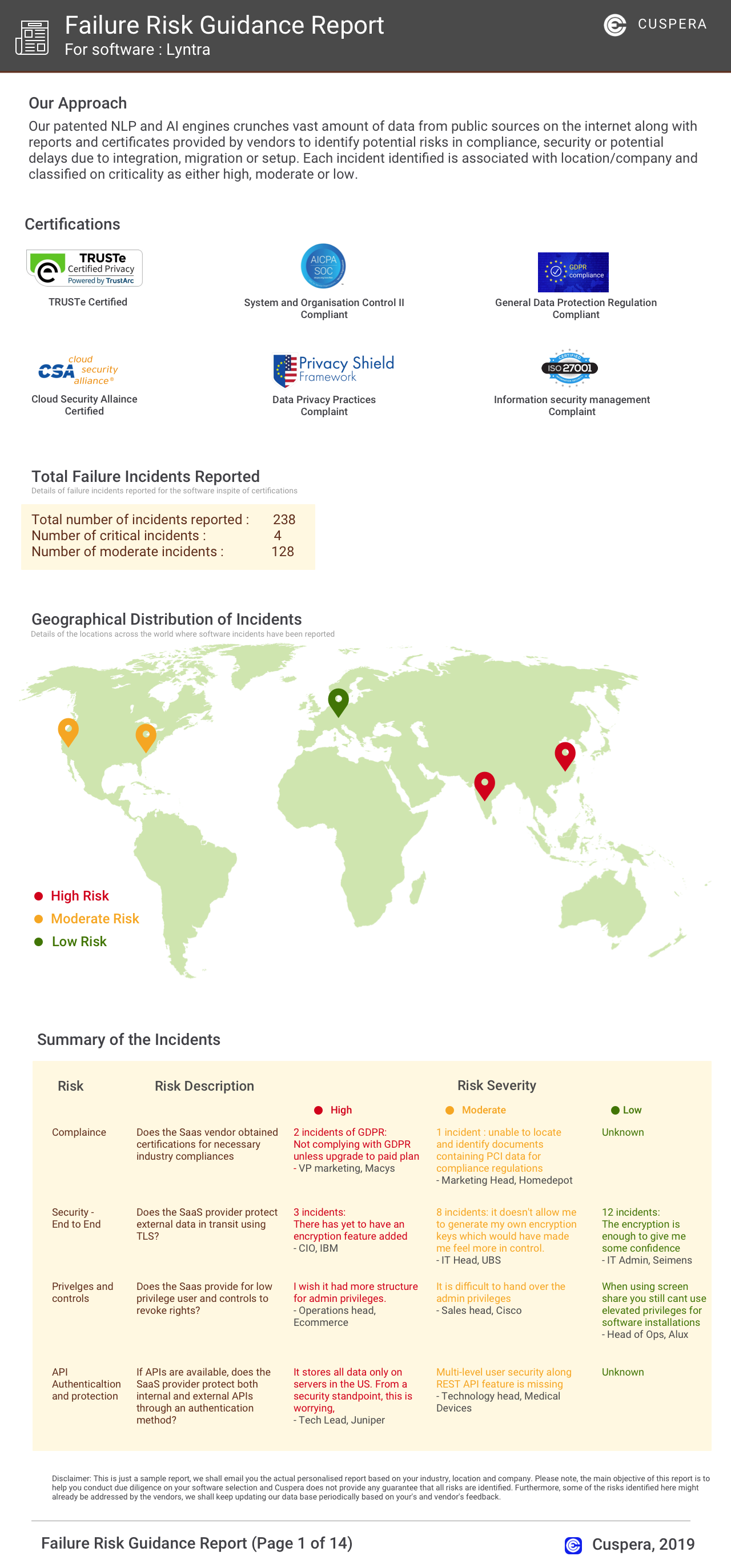
Software Failure Risk Guidance
?for CARTO Platform
Overall Risk Meter
Top Failure Risks for CARTO Platform
CartoDB, Inc. News
Vibe coding spatial apps with CARTO for Agents
CARTO introduced "CARTO for Agents," a GIS platform designed for the Agentic Enterprise. It enables coding agents to rapidly develop geospatial applications using CARTO's CLI and Agent Skills. The platform supports integration with various JS frameworks and enhances app functionality with AI-driven features, offering secure data access and customizable design elements for scalable, high-performance geospatial solutions.
AI-assisted spatial analysis with coding agents and CARTO
CARTO has introduced "CARTO for Agents," a GIS platform designed for the Agentic Enterprise. This platform allows coding agents to automate geospatial workflows using CARTO's tools, enhancing spatial analysis capabilities. Key features include CARTO Agent Skills for specific analyses, integration with data warehouses, and reusable workflows. This innovation aims to streamline spatial analysis processes and improve efficiency for GIS teams.
Introducing CARTO for Agents, GIS for the Agentic Enterprise
CARTO has launched "CARTO for Agents," a GIS platform designed for the Agentic Enterprise, enabling seamless collaboration between humans and AI agents in spatial analytics. The platform includes an extended CARTO CLI, CARTO Agent Skills, and a richer CARTO MCP Server, allowing AI agents to perform end-to-end operations like data connection, spatial analysis, and map publishing without traditional UI. This innovation integrates with major agentic platforms, enhancing geospatial workflows.
CARTO on Gemini Enterprise Agent Marketplace
CARTO has launched its Site Selection AI Agent on Google's Gemini Enterprise platform. This AI tool simplifies complex geospatial analysis into natural-language interactions, enabling users to make data-driven location decisions without coding. It offers direct site comparisons and market discovery, leveraging Google Maps and BigQuery for enhanced analytics. The agent democratizes access to advanced geospatial insights, supporting industries like retail, real estate, logistics, and financial services in optimizing expansion strategies.
CartoDB, Inc. Profile
Company Name
CartoDB, Inc.
Company Website
//carto.comHQ Location
307 5th Ave, New York, New York 10016, US
Employees
101-250
Social
Financials
SERIES C